For the geek in you...
Yesterday I spent some time that I didn't have finally exploring some of the usefulness of this whiz-bang technology among me, particularly my GPS monitor and its software and web functions. Some interesting stuff that, if you tape the bridge of your glasses or wear a pocket-protector, you might find useful. I provide all of this knowing that hardly anybody will care. S'okay, I am still amused.
First off, I have this cool little feature that will give you a kind of real-time analysis of this weekend's bike course at the Liberty Triathlon Half Ironman. This data is captured from my Century ride on May 20th, when I rode the course...I'm not sure if or how much the course this weekend might be different than this, but I think this is pretty close. You'll see that I go around 4 times - the Half will only go around twice. Here's a small screenshot - if you go ahead and keep reading, what you'll see if you go through it yourself is a huge, full size thing in your web browser.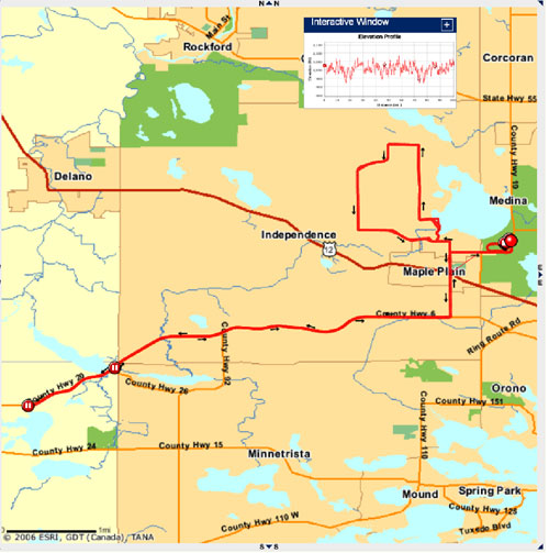
To see the cool stuff, you'll have to go here.. You'll see this little ball follow the path of the course, and most interesting is the synchronized elevation meter that follows the ball around. So you can see both the linear progress, and how much I'm climbing or descending at the same time. For you I suppose this will be interesting at best, but you can see it's practical applications for me, especially in consideration of Ironman.
A few hoops to jump through: You'll need to download Adobe's SVG Viewer. It's a free and fast download. You'll also have to be on a Windows machine (puke), and you have to use Internet Explorer 6.0 or later (really puke). You'll want to, when going to the link, click on the lower "Dashboard" button, and/or when inside any of the dashboards, click on the Map Player tab on the upper right of the viewing screen.
Somehow less useful but more visually interesting is checking out the course at Google Earth. 
This lets you see the course or any pieces of it in absurd detail - here's a shot of the lake where the swim/bike/run all start from:
It also lets you play a cool kind of fly-by, where you're kind of hovering over the earth and following the path of my bike ride. It's really cool, but not entirely practical as a training tool. I suppose if there was a way for the 3D stuff to be actually topographical, that might change everything. Anyway, if you're still reading this and really, really have your geek on and feel like all you want to do today is jump through hoops, you should first download Google Earth - it's an application, not a website, so it'll install on your computer and it works on both Mac and Windows. It's free, too. And it's cool for other stuff, like directions and seeing where restaurants or gas stations are when travelling or zooming into your house. Once you have it installed, and you're itching for another hoop, you'll need to download my files for the Half Ironman and Ironman course, which you can do here. Save that to your computer and unzip it (Mac - doubleclick, Windows, right-click and choose "extract all"), then open it up in Google Earth and there you go.
More interesting, then, is the Ironman course, where you can really get a sense for how dramatic the elevation changes are on this course, and how frequent. 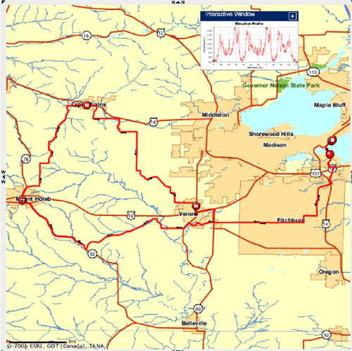
Here I'm actually linking you to somebody else's actual raceday data from last year, so you can see the entire course. Here's the map animation, and again, here's the Google Earth file. SLS or Wil or anybody doing IMWI, you might actually find it useful to take the time to jump through all these hoops, as it is pretty interesting information. The rest of you, it does as good a job as anything I can think of of bringing you along for the ride a bit. Pretty cool. Here's the view from Google Earth - something about satellites and resolution, but you can't zoom in with as much detail on the IM course, FYI.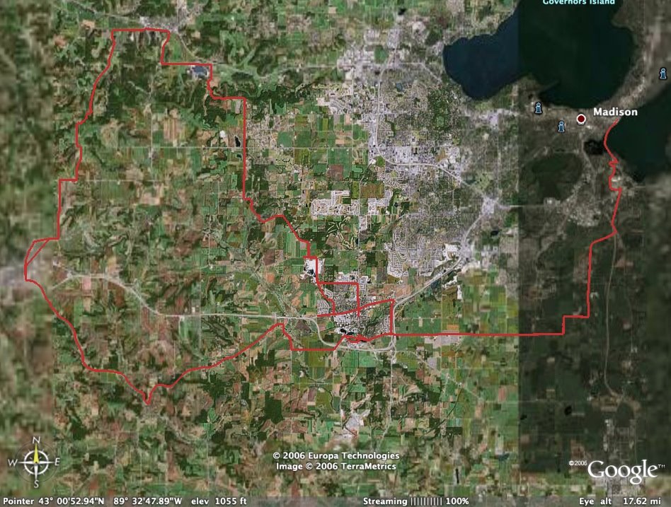
So. If you have any problems with any of it, or something's not working right, or whatever, then sorry about that. Check the help files and stuff, cuz I probably won't be providing much technical assistance here at ye olde blog.
Pretty insane, what they can do with these whiz-bang computers these days. In my day we cut a hole in a box, put a chicken in it and made it dance. Now that was entertainment. Anyway, if anybody actually does all this (the good news is, all these installations and stuff only need to happen once, so from here on out you'd be golden) and finds it interesting, let me know and I can post some of this data for my more interesting races/training rides, etc.

3 comments:
Brilliant! That's a friggin' awesome idea. And then you could throw stuff at virtual me and run me off the road and stuff. So it was useful? Not too major of a hassle? Did you happen to try the GoogleEarth stuff?
This stuff will go great with my pocket protector ;-)
Actually, I find it really interesting as well. I'm another Motionbased user (kyillee on there, too). I find it really helpful to check out other rides people have done of areas I will be racing, and I love how well it keeps track of my bikes, runs, etc. If anyone needs the IMAZ course, the 2005 version is up there from a number of people.
The Motionbased website is actually build using some of the software that I work on, which is fun for me since I love that site. And if they wanted the could give other icons to have go around the map... it could be fun ;-)
I've used Google Earth (shh... don't tell the people I work with), but never with GPS stuff. I might have to check that out later.
I love that there are other geeks among me. Cool that you work in software development, Kylie. I hadn't spent any time in GoogleEarth before yesterday, either, but saw it as an export option at Motionbased, so gave it a try. I see some real usefulness in Motionbased, especially the kind of real-time analysis it gives you. Between that, the Garmin software that comes with the watch and Training Peaks, where I log stuff...man, it can get a little overloaded with the geekiness. But I'm just starting to explore Motionbased, so I'm pretty geeked about its potential.
Post a Comment